 The development of accurate maps was one of humankind’s biggest advances (after learning to talk) that enabled exploration and other developments. Mobile and online technology have advanced mapping (especially timely access to accurate maps) in ways that only a few years ago, most of us could never have imagined. The development of accurate maps was one of humankind’s biggest advances (after learning to talk) that enabled exploration and other developments. Mobile and online technology have advanced mapping (especially timely access to accurate maps) in ways that only a few years ago, most of us could never have imagined.
Automated maps in cars have been around for quite a while but it was only the widespread availability of GPS and the falling cost of electronics that made it feasible to think of sat nav as standard kit for lots of cars, though it doesn’t stop some gouging car makers from charging a healthy premium for installing a system that is years-old in design and will be completely obsolete by the time the user gets their next smartphone.
Most of us can remember the first time we saw Google Earth – spent a while looking up where we live, where we used to live, where we’ve been on holiday etc. Amazingly, though, Google didn’t know what they were going to do with the technology when they acquired it, but figured if they build it and people start using it, they’ll figure out how to monetise that later. And they did.
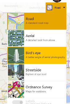
Bing Maps
Microsoft has its own mapping technologies, of course – sometimes developed in partnership or licensed from 3rd parties, and there are a couple of places where they stand out from those available elsewhere: the Birds Eye view in Bing Maps shows some cracking imagery, for example.
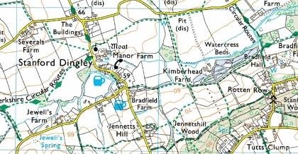
If you’re set to use Bing Maps in the UK (go to the gear icon on the top right, click Settings, Region and choose United Kingdom) then you’ll also get access to the Ordnance Survey* maps which show topographical features, footpaths, bridleways, landmarks and all sorts – see above map of part of an old bit of West Berks as an example.
Windows 10 PC & Mobile
 Windows 8.x had a Maps app that was interesting to a degree, but didn’t really offer much more than you’d get in a browser (apart from offline support) . HERE Maps still publishes a decent app for PC users, though it’s still not a lot more than you’d get if you just went to a mapping site like Bing, or HERE.com itself. The new HERE site doesn’t even promote the Windows app, so make of that what you will. Windows 8.x had a Maps app that was interesting to a degree, but didn’t really offer much more than you’d get in a browser (apart from offline support) . HERE Maps still publishes a decent app for PC users, though it’s still not a lot more than you’d get if you just went to a mapping site like Bing, or HERE.com itself. The new HERE site doesn’t even promote the Windows app, so make of that what you will.
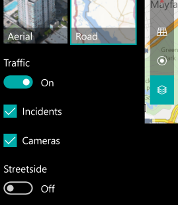  There is a new Maps app for Windows 10 mobile & PC, that is quite a bit better, though. The app lets you download maps locally and will also function as a sat nav if you have a GPS in your device – so either a Windows 10 Mobile device (aka a phone) or some sort of tablet thing could be used in-car, with turn-by-turn directions, 3D views etc. There is a new Maps app for Windows 10 mobile & PC, that is quite a bit better, though. The app lets you download maps locally and will also function as a sat nav if you have a GPS in your device – so either a Windows 10 Mobile device (aka a phone) or some sort of tablet thing could be used in-car, with turn-by-turn directions, 3D views etc.
There are essentially 3 cool features about the maps app that set it apart from others, especially when used on a phone with Windows 10 Mobile:
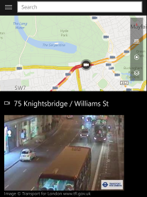
- Traffic and Cameras – by turning on the traffic or cameras options, you’ll see what the state of the roads are, and if you tap on the camera icons shown, you’ll see a recent – but sadly not date or time-stamped – image of the scene
 StreetSide view – if you’re in the area covered by the subset of the world where a scene has been recorded by the StreetSide camera wagon, then you’ll see imagery on your device StreetSide view – if you’re in the area covered by the subset of the world where a scene has been recorded by the StreetSide camera wagon, then you’ll see imagery on your device- Car favourites – don’t recreate Dude, Where’s My Car? – you can add a Favourite (press the hamburger icon on the top left, choose Favourites, and you’ll see a
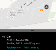 list of favourite places, including Home, Work and, now, Car). You set the current location of your car and optionally add a photo from the camera, so if you want to record the zone/row location sign in the airport, or the situ and registration number of the potential door-swinger parked next to you so you might have some proof when they ding your car… list of favourite places, including Home, Work and, now, Car). You set the current location of your car and optionally add a photo from the camera, so if you want to record the zone/row location sign in the airport, or the situ and registration number of the potential door-swinger parked next to you so you might have some proof when they ding your car…
* The Ordnance Survey is one of the oldest mapping organisations in the world, tracing its history back to the aftermath of some troublesome northerners planning to install an itinerant French waif as their king.
[Billy Connolly – ergo, seriously, NSFW – has a few words to say about BPC] |


