A worked example of using spatial and olap data in Reporting Services part 2
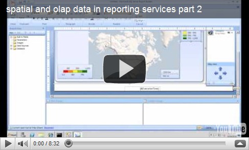
Following on from my my post on Monday I wanted to show you how to link reports together using the mapping control in Report Builder 3. This is actually pretty easy to do as any polygon or point on a map can have an action associated with it and one of the available action types allows you to call another report.The clever bit is that the polygon has data associated with it so you can pass this information as a parameter to another report. In my example I have a US State report which is run merely by clicking on the state in the USA wide overall sales map I created my last post.

I have made a screencast for you to follow and if you want to try it for yourself then please refer to part 1 I posted on Monday as you’ll need understand that first..